
Tampa Under a Tropical Storm Warning as Eta Closes in on Florida's West Coast
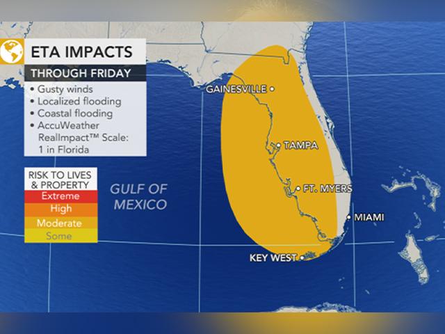
Hours after regaining hurricane force on Wednesday morning as it started moving northeastward over the Gulf of Mexico, Eta weakened into a tropical storm just west of Florida early in the afternoon. Still, forecasters are predicting that the storm will make a second U.S. landfall along Florida’s Gulf coast as a 1 on the AccuWeather RealImpact™ Scale— potentially bringing a rare strike to the Tampa and St. Petersburg area.
A hurricane watch was in effect for the area Wednesday, which has become known for dodging hurricane landfalls. Churning over the Gulf just 145 miles south-southwest of Tampa, the storm was on the move again Wednesday morning. It was heading to the north-northeast at 15 mph — one day after it had sat stationary off the western tip of Cuba, triggering additional flooding concerns for western parts of the island nation and South Florida.
Eta’s maximum sustained winds were 75 mph Wednesday morning — just 1 mph over what’s needed for a storm to be considered a Category 1 hurricane. Tropical-storm-force winds extend outward up to 115 miles (185 km/h) from the center of Eta.
The outer fringes of rain and gusty winds were already lashing at the west coast of the Florida Peninsula on Wednesday morning from Tampa to Marco Island. These areas, as well as locations farther to the north along the Florida west coast, will experience tropical-storm-force wind gusts between 40 and 60 mph.
AccuWeather National Reporter Jonathan Petramala shared a video on Twitter of surf beginning to come up ahead of Eta in St. Petersburg Beach Wednesday morning.
Forecasters expect Eta to make landfall along the upper portion of the west coast of the Florida Peninsula -- between Clearwater and Cedar Key -- late Wednesday night or Thursday morning as a strong tropical storm or Category 1 hurricane.
Regardless of whether or not Eta hits as a tropical storm or a Category 1 hurricane on the Saffir Simpson scale, AccuWeather meteorologists expect Eta to have the impact of 1 on the AccuWeather RealImpact™ Scale for hurricanes, which factors in a broad range of the impacts, including flooding rain, storm surge, wind and economic losses, while the Saffir-Simpson scale categorizes hurricanes based solely on maximum sustained winds.
(Image credit: Accuweather)
The last time that a hurricane-impacted part of Tampa was when Irma rampaged up the Sunshine State in 2017, delivering a glancing blow as a weakened Category 1 hurricane to eastern parts of the city. Still, Irma technically made a direct hit and the storm caused damage, power outages, and a rare spectacle for those who had not evacuated ahead of the storm -- a blowout tide that emptied parts of Tampa Bay.
Similar to Irma, Hurricane Charley in 2004 was initially forecast to track into the Tampa area, but the dangerous Category 4 storm, packing 150-mph winds, suddenly veered northeastward, sparing the region and making landfall about 90 miles farther the south in Cayo Costa, Florida, instead.
Prior to Hurricane Irma, the last time Tampa Bay sustained a direct hit by a hurricane was in October 1921, nearly a full century ago, even before hurricanes were given names. Known as "the forgotten nightmare,” according to the National Weather Service, the hurricane killed at least eight people and left behind widespread destruction
AccuWeather's top hurricane expert Dan Kottlowski predicted that the storm's north-northeasterly movement will continue as it tracks toward Florida's west coast, but it will make a last-minute turn more toward the northeast, affecting where landfall occurs.
"The question here is how quickly does the storm turn more to the northeast as it moves along. This makes a difference with not only the landfall point, but also timing of the storm's strong tropical storm to hurricane conditions, and where the biggest storm surge might occur," Kottlowski explained.
Should the storm track in near Clearwater, then a significant storm surge could focus on Tampa Bay, Florida. At this time a storm surge of 1-3 feet is forecast near and just south of the center of the storm with a local storm surge of up to 6 feet possible.
Predicted winds of 40-60 mph strong can knock down trees, cause power outages, and cause loose items to turn into projectiles. An AccuWeather Local StormMax™ wind gust of 80 mph is forecast near and just south of where the eye makes landfall. Winds this strong can cause property damage, and tear off poorly-constructed roofs.
"In addition to the strong wind gusts, there is the potential for tornadoes to be spawned over the Florida Peninsula and waterspouts to develop along the shoreline of the landmass through Thursday," according to AccuWeather Senior Meteorologist Bill Deger.
Tornadoes and waterspouts could spin up within the spiral bands of the storm. Forecasters emphasized the importance of heeding all warnings, noting that some of the tornadoes may be hard to see as they could be rain-wrapped.
And Eta already has a history of unleashing torrential rainfall in Florida. Eta dumped up to 18 inches on South Florida Sunday into Monday, causing widespread flooding of streets and low-lying locations in the Miami and Fort Lauderdale, Florida. The storm made its first landfall with 65-mph winds on Lower Matecumbe Key, Florida, on Sunday night.
The heaviest rain from Eta during Wednesday into Thursday will avoid areas hit the hardest by torrential downpours earlier this week, but a general 2-8 inches of rain is anticipated to drench much of the western half of the peninsula with an AccuWeather Local StormMax™ of 14 inches anticipated.
But even in some of the central and eastern parts of the Florida Peninsula, downpours could lead to localized flooding as locally strong wind gusts could develop in the storm's outer rainbands. Cities such as Winter Haven, Orlando, Ocala and Gainesville, Florida, could even face sporadic power outages.
After Eta makes landfall and pushes inland, the system will trek across the northern part of the Florida Peninsula on Thursday. After that, it is expected to push offshore of Florida's upper Atlantic coast on Thursday night.
Eta is forecast to gradually lose wind intensity as it moves over land, but gusty and locally damaging winds are forecast to spread as Eta moves along over the peninsula.
"From later Thursday to Friday, rain and localized flooding from Eta will spread into northern Florida and Georgia," AccuWeather Senior Meteorologist Rob Miller said.
CLICK HERE FOR THE FREE ACCUWEATHER APP
Then, Eta could lurk over western Atlantic waters for a time.
"From Friday onward, Eta will continue to weaken and could either be absorbed by a cold front or could stay separated from the front and possibly circle waters of the western Atlantic for several days," Kottlowski said.
AccuWeather forecasters have already been monitoring Eta for weeks and warning that it could be a concern for quite some time. Eta was first named a tropical storm on Saturday, Oct. 31, making 2020 tie the 2005 record for most named systems to develop in one hurricane season.
Theta, another system that formed out in the central Atlantic Monday evening, since broke that record when it became the 29th organized tropical system of the year.
And the season isn’t over yet. Meteorologists are keeping an eye on another disturbance that could brew in the Caribbean Sea by the weekend. The system could head toward Central America, potentially threatening renewed flooding for areas recently devastated by Eta. The next tropical storm to develop will be given the name Iota.
It has been more than a week since Eta's calamitous impacts in Central America where it produced devastating flooding and mudslides, killing over 50 people in Guatemala alone. Eta struck Nicaragua as a Category 4 storm, only the fifth storm to make landfall at that intensity or stronger in the nation’s history.
The Atlantic hurricane season doesn’t officially end until Nov. 30 — and there could be tropical concerns well into December this year.
STAY UP TO DATE WITH THE FREE CBN NEWS APP
Click Here Get the App with Special Alerts on Breaking News and Top Stories


